Home
| About
| Mine Tracker
| RSS
| Footer
▄▄▄▄▄▄▄▄▄▄▄▄▄▄▄▄▄▄▄▄▄▄▄▄▄▄▄▄▄▄▄▄▄▄▄▄▄▄▄▄▄▄▄▄▄▄▄▄▄▄▄▄▄▄▄▄▄▄▄▄▄▄▄▄▄▄▄▄▄▄▄▄▄▄▄▄▄▄▄▄▄▄▄▄▄▄▄▄▄▄▄▄▄▄▄▄
█▄▄░▄▄█░▄▄▀█░▄▄▀█▀▄▀█░▄▄███░▄▄▀█░▄▄▀█░▄▀███▄▄░▄▄█░▄▄▀█░▄▄▀█▀▄▀█░▄▄█░▄▄▀█░▄▄▀██▄██░███▄██▄░▄█░██░
███░███░▀▀▄█░▀▀░█░█▀█░▄▄███░▀▀░█░██░█░█░█████░███░▀▀▄█░▀▀░█░█▀█░▄▄█░▀▀░█░▄▄▀██░▄█░███░▄██░██░▀▀░
███░███▄█▄▄█▄██▄██▄██▄▄▄███▄██▄█▄██▄█▄▄██████░███▄█▄▄█▄██▄██▄██▄▄▄█▄██▄█▄▄▄▄█▄▄▄█▄▄█▄▄▄██▄██▀▀▀▄
▀▀▀▀▀▀▀▀▀▀▀▀▀▀▀▀▀▀▀▀▀▀▀▀▀▀▀▀▀▀▀▀▀▀▀▀▀▀▀▀▀▀▀▀▀▀▀▀▀▀▀▀▀▀▀▀▀▀▀▀▀▀▀▀▀▀▀▀▀▀▀▀▀▀▀▀▀▀▀▀▀▀▀▀▀▀▀▀▀▀▀▀▀▀▀▀
All the Places;
https://www.alltheplaces.xyz/

A growing set of web scrapers designed to output consistent geodata about as many places of business in the world as possible.
https://www.alltheplaces.xyz/
A growing set of web scrapers designed to output consistent geodata about as many places of business in the world as possible.
One company nickel supply chain
https://nornickel.com/business/on-the-map/

Nornickel is the leader in the metals and mining industry in Russia and globally
https://nornickel.com/business/on-the-map/
Nornickel is the leader in the metals and mining industry in Russia and globally
New study reveals fine detail on location and scale of mining sites worldwide
https://news.mongabay.com/2023/05/new-study-reveals-fine-detail-on-location-and-scale-of-mining-sites-worldwide/
We live at the center of a spiderweb of global mining supply chains. The vehicle that took you to the market, the rechargeable battery in your headphones, and the phone or computer you’re reading this article on right now — all required the extraction, processing, transport and sale of minerals that likely originated from points all over the planet. But measuring the cumulative impact of these supply chains, which can span multiple continents and involve dozens of entities, formal and informal, is a tricky business. A new study published in the journal Communications Earth & Environment may have just given a big boost to anyone looking for a clear picture of what those supply chains look like at their point of origin. Using high-resolution satellite data, researchers meticulously pored over images from across the globe, isolating and marking the boundaries of a combined 65,585 square kilometers (25,323 square miles) of mining sites. The data set, which includes large-scale mining operations as well as informal artisanal sites, is one of the most detailed ever created. And to make sure that others can build off their work, the study’s authors have made it available to the public for free.
Environmental Justice Atlas
https://ejatlas.org/

The environmental justice atlas documents and catalogues social conflict around environmental issues. Across the world communities are struggling to defend their land, air, water, forests and their livelihoods from damaging projects and extractive activities with heavy environmental and social impacts: mining, dams, tree plantations, fracking, gas flaring, incinerators, etc. As resources needed to fuel our economy move through the commodity chain from extraction, processing and disposal, at each stage environmental impacts are externalized onto the most marginalized populations. Often this all takes place far from the eyes of concerned citizens or consumers of the end-products.
https://ejatlas.org/
The environmental justice atlas documents and catalogues social conflict around environmental issues. Across the world communities are struggling to defend their land, air, water, forests and their livelihoods from damaging projects and extractive activities with heavy environmental and social impacts: mining, dams, tree plantations, fracking, gas flaring, incinerators, etc. As resources needed to fuel our economy move through the commodity chain from extraction, processing and disposal, at each stage environmental impacts are externalized onto the most marginalized populations. Often this all takes place far from the eyes of concerned citizens or consumers of the end-products.
LEGO supply Chain
https://www.lego.com/cdn/cs/aboutus/assets/blt75660d26d6a7e08c/LEGO_Global_Supply_Chain_Network.pdf

https://www.lego.com/cdn/cs/aboutus/assets/blt75660d26d6a7e08c/LEGO_Global_Supply_Chain_Network.pdf
Map of the Belt and Road Initiative
https://www.clingendael.org/publication/new-map-belt-and-road-initiative
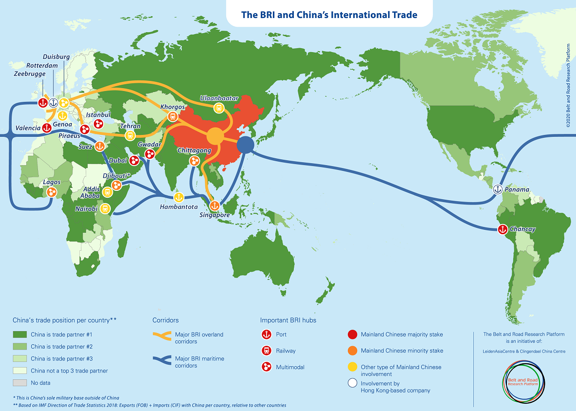
The Belt and Road Research Platform has developed a new map to display the Belt and Road Initiative in relation to China’s international trade. Although there are already plenty of maps which attempt to display the Belt and Road Initiative, we believe that there was a need for a novel approach: integrating the BRI into China’s international trade patterns.
https://www.clingendael.org/publication/new-map-belt-and-road-initiative
The Belt and Road Research Platform has developed a new map to display the Belt and Road Initiative in relation to China’s international trade. Although there are already plenty of maps which attempt to display the Belt and Road Initiative, we believe that there was a need for a novel approach: integrating the BRI into China’s international trade patterns.
Map of Lithium Reserves
https://www2.bgs.ac.uk/mineralsuk/download/global_critical_metal_deposit_maps/G2122_052_V4CMYK.pdf
https://www2.bgs.ac.uk/mineralsuk/download/global_critical_metal_deposit_maps/G2122_052_V4CMYK.pdf
M&S Interactive Supplier Map
https://interactivemap.marksandspencer.com/
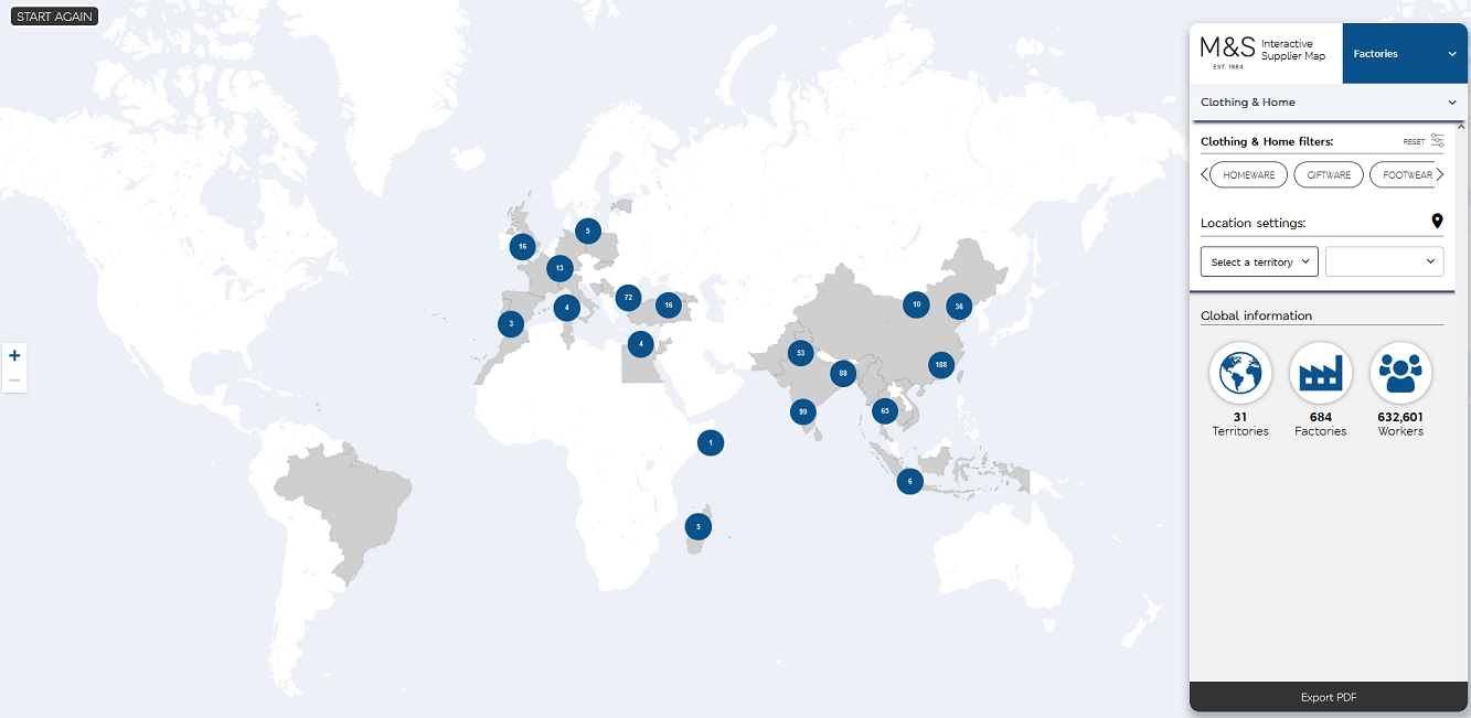
The M&S interactive supplier map is really something. Fresh data, product type filters, adresses, gender distributions, trade union presence, product informtion, certifications, it's all there.
https://interactivemap.marksandspencer.com/
The M&S interactive supplier map is really something. Fresh data, product type filters, adresses, gender distributions, trade union presence, product informtion, certifications, it's all there.
Landscapes of Trade
https://mertennefs.eu/landscapes-of-trade/

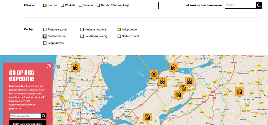
Logistiek is een onlosmakelijk deel van ons dagelijks leven, en een cruciaal ingrediënt van de circulaire economie. Tegelijkertijd groeit de kritiek omtrent de ‘verdozing’ van het landschap door grote distributiecentra, vaak gerelateerd aan e-commerce. De ruimtelijke voetafdruk en gemiddelde grootte van een loods zijn sinds 1980 verviervoudigd. Hierdoor neemt congestie van wegen toe en gaat de kwaliteit van leven achteruit. Deze kaart is een vereenvoudigde weergave van de ruimtelijke dataset die onderzoeker Merten Nefs gebruikt in zijn promotieonderzoek Landscapes of trade - een samenwerking van TU Delft, Erasmus School of Economics en Vereniging Deltametropool. De kaart is bedoeld voor iedereen die inzicht wil krijgen in het ruimtelijk patroon van logistiek in Nederland, en in het bijzonder de goederenvervoer corridor Oost/Zuidoost, de meest intensieve van Nederland.
https://mertennefs.eu/landscapes-of-trade/
Logistiek is een onlosmakelijk deel van ons dagelijks leven, en een cruciaal ingrediënt van de circulaire economie. Tegelijkertijd groeit de kritiek omtrent de ‘verdozing’ van het landschap door grote distributiecentra, vaak gerelateerd aan e-commerce. De ruimtelijke voetafdruk en gemiddelde grootte van een loods zijn sinds 1980 verviervoudigd. Hierdoor neemt congestie van wegen toe en gaat de kwaliteit van leven achteruit. Deze kaart is een vereenvoudigde weergave van de ruimtelijke dataset die onderzoeker Merten Nefs gebruikt in zijn promotieonderzoek Landscapes of trade - een samenwerking van TU Delft, Erasmus School of Economics en Vereniging Deltametropool. De kaart is bedoeld voor iedereen die inzicht wil krijgen in het ruimtelijk patroon van logistiek in Nederland, en in het bijzonder de goederenvervoer corridor Oost/Zuidoost, de meest intensieve van Nederland.
Is There a Mega Warehouse Near You?
https://www.sierraclub.org/sierra/map-mega-warehouses-near-you

The explosion of online shopping has led to a frenzy of warehouse construction in almost every region of the United States. To accommodate the flow of merchandise, Amazon and other online retailers have built what they call “fulfillment centers” in key hubs where zoning is welcoming (or nonexistent) and land is cheap. Today in the United States, there are 39,116 warehouses and distribution centers larger than 100,000 square feet, and they can be found in rural and suburban areas as well as urban ones. For nearby residents, the arrival of the mega warehouses means that traffic noise and air pollution bombard them at all times of the day, all year. But not everyone is impacted equally by the explosion of e-commerce. Often, the consequences fall hardest on communities of color. Use this map to view the distribution of mega-warehouses in your city or state.
https://www.sierraclub.org/sierra/map-mega-warehouses-near-you
The explosion of online shopping has led to a frenzy of warehouse construction in almost every region of the United States. To accommodate the flow of merchandise, Amazon and other online retailers have built what they call “fulfillment centers” in key hubs where zoning is welcoming (or nonexistent) and land is cheap. Today in the United States, there are 39,116 warehouses and distribution centers larger than 100,000 square feet, and they can be found in rural and suburban areas as well as urban ones. For nearby residents, the arrival of the mega warehouses means that traffic noise and air pollution bombard them at all times of the day, all year. But not everyone is impacted equally by the explosion of e-commerce. Often, the consequences fall hardest on communities of color. Use this map to view the distribution of mega-warehouses in your city or state.