Home
| About
| Mine Tracker
| RSS
| Footer
▄▄▄▄▄▄▄▄▄▄▄▄▄▄▄▄▄▄▄▄▄▄▄▄▄▄▄▄▄▄▄▄▄▄▄▄▄▄▄▄▄▄▄▄▄▄▄▄▄▄▄▄▄▄▄▄▄▄▄▄▄▄▄▄▄▄▄▄▄▄▄▄▄▄▄▄▄▄▄▄▄▄▄▄▄▄▄▄▄▄▄▄▄▄▄▄
█▄▄░▄▄█░▄▄▀█░▄▄▀█▀▄▀█░▄▄███░▄▄▀█░▄▄▀█░▄▀███▄▄░▄▄█░▄▄▀█░▄▄▀█▀▄▀█░▄▄█░▄▄▀█░▄▄▀██▄██░███▄██▄░▄█░██░
███░███░▀▀▄█░▀▀░█░█▀█░▄▄███░▀▀░█░██░█░█░█████░███░▀▀▄█░▀▀░█░█▀█░▄▄█░▀▀░█░▄▄▀██░▄█░███░▄██░██░▀▀░
███░███▄█▄▄█▄██▄██▄██▄▄▄███▄██▄█▄██▄█▄▄██████░███▄█▄▄█▄██▄██▄██▄▄▄█▄██▄█▄▄▄▄█▄▄▄█▄▄█▄▄▄██▄██▀▀▀▄
▀▀▀▀▀▀▀▀▀▀▀▀▀▀▀▀▀▀▀▀▀▀▀▀▀▀▀▀▀▀▀▀▀▀▀▀▀▀▀▀▀▀▀▀▀▀▀▀▀▀▀▀▀▀▀▀▀▀▀▀▀▀▀▀▀▀▀▀▀▀▀▀▀▀▀▀▀▀▀▀▀▀▀▀▀▀▀▀▀▀▀▀▀▀▀▀
Environmental Justice Atlas
https://ejatlas.org/

The environmental justice atlas documents and catalogues social conflict around environmental issues. Across the world communities are struggling to defend their land, air, water, forests and their livelihoods from damaging projects and extractive activities with heavy environmental and social impacts: mining, dams, tree plantations, fracking, gas flaring, incinerators, etc. As resources needed to fuel our economy move through the commodity chain from extraction, processing and disposal, at each stage environmental impacts are externalized onto the most marginalized populations. Often this all takes place far from the eyes of concerned citizens or consumers of the end-products.
https://ejatlas.org/
The environmental justice atlas documents and catalogues social conflict around environmental issues. Across the world communities are struggling to defend their land, air, water, forests and their livelihoods from damaging projects and extractive activities with heavy environmental and social impacts: mining, dams, tree plantations, fracking, gas flaring, incinerators, etc. As resources needed to fuel our economy move through the commodity chain from extraction, processing and disposal, at each stage environmental impacts are externalized onto the most marginalized populations. Often this all takes place far from the eyes of concerned citizens or consumers of the end-products.
Map of the Belt and Road Initiative
https://www.clingendael.org/publication/new-map-belt-and-road-initiative
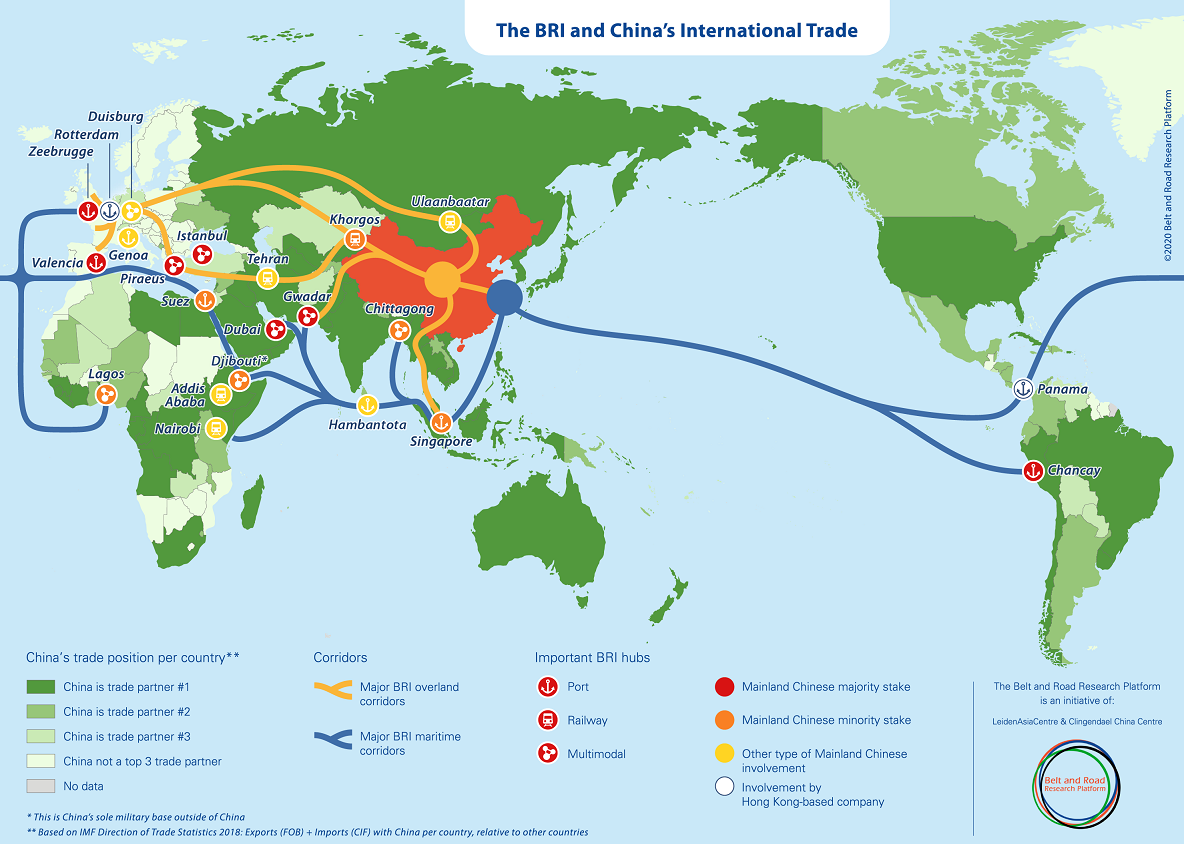
The Belt and Road Research Platform has developed a new map to display the Belt and Road Initiative in relation to China’s international trade. Although there are already plenty of maps which attempt to display the Belt and Road Initiative, we believe that there was a need for a novel approach: integrating the BRI into China’s international trade patterns.
https://www.clingendael.org/publication/new-map-belt-and-road-initiative
The Belt and Road Research Platform has developed a new map to display the Belt and Road Initiative in relation to China’s international trade. Although there are already plenty of maps which attempt to display the Belt and Road Initiative, we believe that there was a need for a novel approach: integrating the BRI into China’s international trade patterns.
Submarine Cable Map 2022
https://submarine-cable-map-2022.telegeography.com/
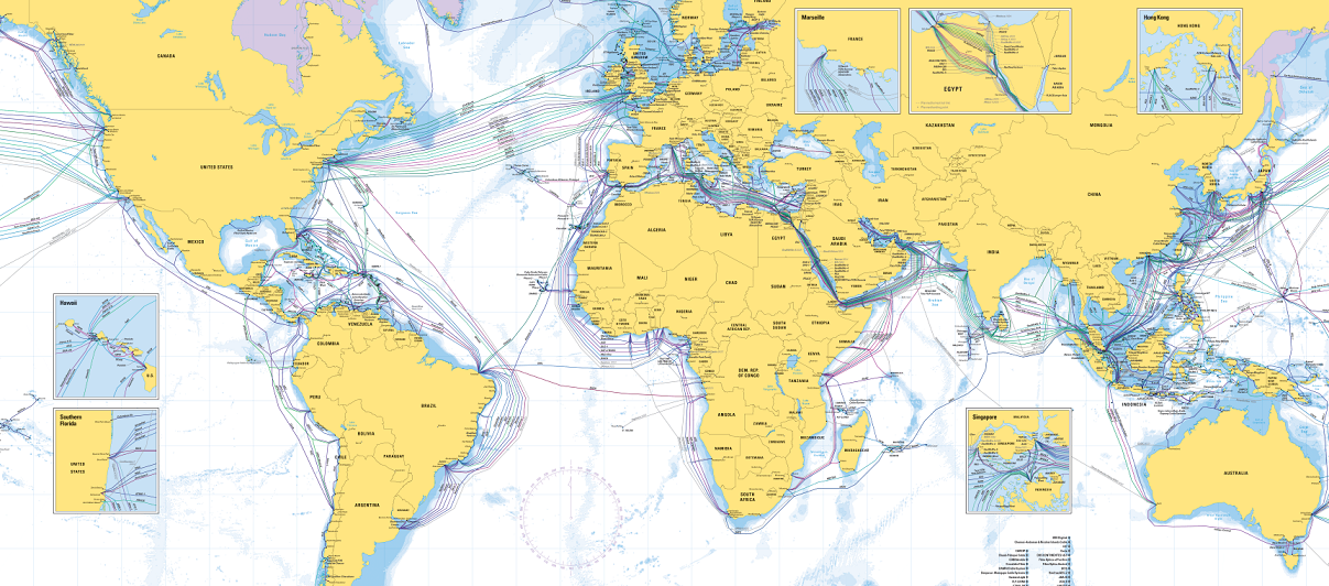
This new edition depicts 486 cable systems and 1,306 landings that are currently active or under construction.
https://submarine-cable-map-2022.telegeography.com/
This new edition depicts 486 cable systems and 1,306 landings that are currently active or under construction.
Climate Trace
https://climatetrace.org/map

We harness satellite imagery and other forms of remote sensing, artificial intelligence, and collective data science expertise to track human-caused GHG emissions with unprecedented detail and speed. Climate TRACE’s emissions inventory is the world’s first comprehensive accounting of GHG emissions based primarily on direct, independent observation. Our innovative, open, and accessible approach relies on advances in technology to fill critical knowledge gaps for all decision makers that rely on the patchwork system of self-reporting that serves as the basis for most existing emissions inventories.
https://climatetrace.org/map
We harness satellite imagery and other forms of remote sensing, artificial intelligence, and collective data science expertise to track human-caused GHG emissions with unprecedented detail and speed. Climate TRACE’s emissions inventory is the world’s first comprehensive accounting of GHG emissions based primarily on direct, independent observation. Our innovative, open, and accessible approach relies on advances in technology to fill critical knowledge gaps for all decision makers that rely on the patchwork system of self-reporting that serves as the basis for most existing emissions inventories.
Landscapes of Trade
https://mertennefs.eu/landscapes-of-trade/

Logistiek is een onlosmakelijk deel van ons dagelijks leven, en een cruciaal ingrediënt van de circulaire economie. Tegelijkertijd groeit de kritiek omtrent de ‘verdozing’ van het landschap door grote distributiecentra, vaak gerelateerd aan e-commerce. De ruimtelijke voetafdruk en gemiddelde grootte van een loods zijn sinds 1980 verviervoudigd. Hierdoor neemt congestie van wegen toe en gaat de kwaliteit van leven achteruit. Deze kaart is een vereenvoudigde weergave van de ruimtelijke dataset die onderzoeker Merten Nefs gebruikt in zijn promotieonderzoek Landscapes of trade - een samenwerking van TU Delft, Erasmus School of Economics en Vereniging Deltametropool. De kaart is bedoeld voor iedereen die inzicht wil krijgen in het ruimtelijk patroon van logistiek in Nederland, en in het bijzonder de goederenvervoer corridor Oost/Zuidoost, de meest intensieve van Nederland.
https://mertennefs.eu/landscapes-of-trade/
Logistiek is een onlosmakelijk deel van ons dagelijks leven, en een cruciaal ingrediënt van de circulaire economie. Tegelijkertijd groeit de kritiek omtrent de ‘verdozing’ van het landschap door grote distributiecentra, vaak gerelateerd aan e-commerce. De ruimtelijke voetafdruk en gemiddelde grootte van een loods zijn sinds 1980 verviervoudigd. Hierdoor neemt congestie van wegen toe en gaat de kwaliteit van leven achteruit. Deze kaart is een vereenvoudigde weergave van de ruimtelijke dataset die onderzoeker Merten Nefs gebruikt in zijn promotieonderzoek Landscapes of trade - een samenwerking van TU Delft, Erasmus School of Economics en Vereniging Deltametropool. De kaart is bedoeld voor iedereen die inzicht wil krijgen in het ruimtelijk patroon van logistiek in Nederland, en in het bijzonder de goederenvervoer corridor Oost/Zuidoost, de meest intensieve van Nederland.
H&M Indian/Bangladesh supply chain
https://www.spglobal.com/en/research-insights/articles/hm-s-supply-chain-technology-investments-pay-off

https://www.spglobal.com/en/research-insights/articles/hm-s-supply-chain-technology-investments-pay-off